


The Limi Valley Trek is a remote, off-the-beaten-path trekking route in the far western part of Nepal, located in Humla District near the Tibetan border. It’s known for its stunning landscapes, deep Himalayan valleys, high mountain views, ancient Tibetan Buddhist culture, and very limited tourist traffic — making it one of Nepal’s most adventurous treks.
The entire trek follows the trail followed by the ancient traders. Even in the modern-day, you will be accompanied by mules, yaks, goats, traders and herders. Hence, taking an unused trail or getting off track may result in unpassable terrain. Following the regular trail used from ancient times does not alter the surreal landscape, fascinating culture and the monasteries and way of life.
Limi valley trek not only showcases you a beautiful and unsoiled terrain but also the folklores and the stories of magic and witches. You would as well enjoy hearing the stories of Yetis, snow leopards and the blue sheep. Furthermore, the Bhutias of the upper Limi valley believed to be the descendants of Tibetans, not only exude an amazing way of life but also enjoy grazing their livestock on the Tibetan side.
Overview
The Limi Valley Trekking, located in the remote Humla District of north-western Nepal, is one of the country’s most culturally preserved Himalayan regions. The history of the Limi Valley Trek is deeply intertwined with ancient Tibetan civilization, trans-Himalayan trade, and centuries-old Buddhist traditions that have remained largely untouched by modern development.
Trip Highlights
- Visit UNESCO World Heritage Site of Kathmandu Durbar Square, Swayambhunath, or Boudhanath in Kathmandu city.
- Enjoy the mesmerizing views of high standing Mt. Kailash (6,638m), Mt. Api (7,132m), Kanjiroba (6,883m), and Mt. Saipal (7,031m) on a clear day.
- Visit the Namkha Khyung Dzong Monastery in Yalbang, which is the biggest in Humla, and Dhungkar Choezom Monastery in Tumkot, which is the only Shakya Monastery in Humla.
- Interact with the people of the ethnic Tibetan Buddhist, Shakya, Thakuri, and Khas communities living in the villages of Dharapori, Kermi, Tumkot, Muchu, Chyadok in Humla.
- Conquer the high passes of Nara La (4620m), Langdogd (4,550m), and Nyalu La (4,990m).
- A scenically and culturally diverse trek over two high passes into the most remote follows the ancient salt trade route and pilgrim's trail of Nepal border and Tibet.
- Trek alongside the banks of the gigantic Karnali river along the route from Simikot towards Limi valley.
- Walk on the ancient caravan trail in Talung valley that meets Limi valley and Mansarovar trail.
- Humla has a strong Buddhist influence, with several monasteries and spiritual sites. The region is part of the ancient trade route to Tibet, which has contributed to its rich cultural heritage
Itinerary
Welcome to Nepal! A representative from Everest Alpine Trekking will receive you at the airport and drop you at your hotel. On this day you will not do much but relax and go around your hotel location.Overnight in Kathmandu.
Thank you for choosing Limi valley trek as your next adventure destination! If you booked this trek long time back your permits are ready before you arrive but if it is a last minute booking you permits will be made on this day. While the back office is busy making permits on the back end, you will get involved in sightseeing some UNESCO world heritage sites. Sometime in the day, you will as well do last minute preparation, packing and purchase if necessary. In the evening you will meet your guide and your guide will brief you about the trek.
There is flight from Kathmandu to Nepalgunj all day around and there are several major carriers that serve in that destination. The flight takes around 50 minutes to reach Nepalgunj and once in Nepalgunj you will be transferred to your hotel. Since there are no day flights to Simikot, you will have to wait for early morning flight following day. Overnight in Nepalgunj.
You will board a smaller aircraft and an early morning one for Simikot. The destination of around 208 kilometers is covered in just an hour time. Once in Simikot, you will call it a day and enjoy the terrain. Furthermore, you will get acquainted and get ready for next day. Overnight in Simikot.
You would climb the trail immediately from the airport and become northbound. From past upper simikot and the simikot water supply, the trail drops steeply for the next 800 meters to Masigaon. After such knee crunching downhill trek the crew will stay here and enjoy the lunch before heading to the final destination of the day. Further down the trail, you will walk along Karnali river all the way to Dharapuri.Overnight in Dharapuri.
After checking in with the police, you march forward. The trail snakes up and down noticeably and reaches to a huts of yak herders by series of 3 waterfall. From here, the trail gets steep and so steep that yaks and mules are often unloaded to climb the hill. From here, the first proper campground is around 5 hrs away and that is of Kermi. Once in Kermi, you can further trek for around 40 minutes to reach to natural hot springs.
The trail out of Kermi climbs up the ridge and opens to a valley with potatoes and barley. The trail then drops to Chumsa Khola where you might come across the pilgrims to Kailash. The trail traverses through beautiful pine forests, mani walls and prayer flag wrapped cairns. However, you will not go all the way down to Chumsa Khola and part ways to the settlements of wider Chumsa khola valley.Overnight in Chumsa Khola Valley.
The day isnt going to be long and the trail climbs steadily from Chumsa Khola. The first half of the trail climbs through beautiful forest of pine and birch covered with mosses. Out the the forest the trail climbs to glacial moraine and further to the expanse of streams that merges in Chumsa Khola. There are 2 camping grounds and you will camp in the Dharmashala by the stream.Overnight in Dharmashala
The day is going to be long and arduous as you have to climb a pass namely Nyu La at 4990 meters. Initially the trail climbs up on grassy hill and then makes its way to moraine. Most of the time, this section of the trail is covered in snow and it is difficult for individuals to find the trail by themselves. On the other hand, the top of the pass is marked with cairns and prayer flags. On a clear day you will be able to view beautiful landscape of Tibet. Furthermore, you will be blessed with the views of Mt. Kailash and Gurla Mandata.Overnight at Talung Camp.
From Talung camp the trail follows the shoreline of Tshom Tsho. The head of the lake Tshom Tsho is dammed by Talung and ling Chu and hence, you will have to climb out of Ling Chu before heading out to Jang. From the top of Ling you will see the trail that leads to Tibet and once a very popular village but now abandoned village of Gumma Yok.Overnight in Jang.
Jang lies at around 4100 meters from the sea level and it is uttermost important to give yourself some rest. Furthermore, the day as well can be used for washing clothes and exploring the area. There are beautiful short hike to the ridge above the village that offers a view of the valley and the village. Furthermore, you can as well explore the only Gompa at the center of the village.Overnight in Jang.
This will not be a long day and it is not very difficult as well. After a long previous day, you can take your time to start the day a little late. However, if you start by 9 you can take your time to explore Rinzing Ling Gompa. The gompa is considered to be the most important in entire Limi. From the gompa climbs the trail to a ridge that allows you to sit and observe the views of Halji and its beautiful fields of wheat and barley.Overnight in the basin of river in Halji.
Til is the last village in the Limi valley and since it is a 10 km walk, you should arrive in time to explore it. The trail climbs out of the western side of the village and drops down to a river and then further heads north. Around 3 - 4 hours from the village and you would reach a large flat area with the views of Phupkharka Himal and Spike Peak. This is your campsite for the day. The village of Til is further 20 minutes ascent and the village Gompa is 30 minutes further from the village.Overnight in Til.
Although the map shows a very short distance from Til to Manepene, the trek takes long time. Be prepared for not a very long distance but a very long day as the trail repeatedly climbs up and down and has some steep ascents and descents. Keep looking for the viewpoint after Lamka Lagna from where you can get the views of south humla and Karnali river raging towards the south. Overnight in Manepene, a campsite with huge rock carved with Om Mane Padme Hum.
The trail continues to snake through ravines but far shorter than the previous day. From the trail you will get the views of extended part of the Tibetan plateau signified by small patches of barley field. You will as well see the Simikot - Hilsa road snake up on a hill side.Overnight in Hilsa.
Out of Hilsa you will avoid the motor road by descending down to the river and climbing up to Rani Pauwa. It is a very good place to stop and catch your breath as well as turn back and get the final glimpse of the Tibetan land. Further down the trail, you will have to cross over a pass namely Nara la. It takes around 4 hours alone to cross the pass. Beyond the pass comes the compact village of Yari before you finally reach to your campsite of Palbang.Overnight in Palbang.
The trail gets much easier and pleasant from this point onwards. Although the initial phase of the trek climbs through the juniper trees, most of the trail is a downhill walk. You will as well come across frequent settlements and trekkers heading to Kailash. From here on, you can as well accommodate in either basic lodges or camp.Overnight in the banks of river at Muchu.
This may be one of the most beautiful days of trek in the Limi valley trek itinerary. The trail mostly is along the beautiful blue Humla Karnali river. You will walk from village after village which is traditional and beautiful. You will cross several bridges and descends down a beautiful forest to finally arrive at Chumsa Khola.Overnight in Chumsa Khola
From Chumsa you will join the trail that you had taken on your way up. On this day you will have completed a full circle.Overnight in Dharapuri.
You will take a lower route to Simikot but you will have to climb a never ending 900 meters to the top of the hill that overlooks Simikot. From the top of the hill the trail drops directly to simikot. Once in Simikot, your guide will reconfirm the flights to Nepalgunj.Overnight in Simikot.
Once in Simikot, your guide will reconfirm the flights to Nepalgunj.
Transfer to hotel in Kathmandu.
Cost Includes
- Airport pick up and drop off by private vehicle.
- Three-night accommodation with breakfast at a 3 or 4-star category hotel in Kathmandu.
- Three meals a day during the trek.
- Best available twin sharing lodge to lodge accommodation during the trek.
- Kathmandu city tours, tour guides, and private transportation.
- One highly experienced, helpful, and friendly guide.
- Porters (1 porter for 2 people) and their food, accommodation, salary, and equipment.
- Accident insurance for all staff.
- Trekking map/ Trekking T-Shirt, duffel bag.
- First aid medical kit, Oximeter to check pulse, heart rate, and oxygen saturation at higher altitude.
- Restricted Area Trek Permit & TIMS Fee- Trekkers' Information Management System (Please bring 2 passport-size photos for permit)
- Worst case, help with all rescue and evacuation arrangements.
- Government taxes & office service charge.
Cost Excludes
- Personal Travel insurance.
- International airfare.
- Nepal entry visa. You can obtain a visa easily upon your arrival at Tribhuwan International Airport in Kathmandu. A multiple-entry tourist visa good for 30 days can be obtained by paying the US $ 40 or equivalent in foreign currency. Similarly, multiple-entry tourist visas for 90 days can be obtained by paying the US $ 100. Please bring 2 passport-size photos.
- Snacks /Drinks and other personal expenses.
- Hot showers during the trek.
- Personal trekking equipment.
- WiFi internet and phone call unless it’s free.
- Tips and gratuities for trekking staff and drivers
FAQS
You should bring walking boots, a sleeping bag, a first aid kit, a headlamp, warm, waterproof clothing, and other trekking equipment. Essential items to pack include extra layers for warmth, a water bottle to stay hydrated, sunscreen, sunglasses, a hat for sun protection, and a sturdy backpack to carry your belongings. Having cash on hand for personal costs and tipping your guide and porter is also advised.
Yes, a permit is required to participate in the Limi Valley Trek. A Restricted Area Permit and a TIMS card is required. It can be obtained in Kathmandu from the Nepal Tourism Board or any other trekking agencies.
On the Humla Limi Valley Trek, permits cost about USD 50 per person per day. Additionally, you must obtain a TIMS card, which costs NPR 2000.
The Nara La Pass, which rises 4,620 meters above sea level, is the highest point on the Limi Valley Trek. Apart from this, the three settlements—Dzang at 3,920m, Halji at 3,700m, and Til at 4,100m above sea level—offer diverse perspectives of the region’s altitude variations.
Dang is the district of Lumbini Province, located in the Inner Terai of mid-western Nepal. It is Asia’s second- largest and Nepal’s largest valley, almost three times bigger than the Kathmandu Valley.
To go to the Limi valley, one first needs to travel to Simikot, the headquarters of district Humla. Presently, the only way of traveling to Simikot, other than going on foot for several days, is to take a flight from Nepalgunj in the western Nepali plains. Limi valley can be accessed from Simikot by two routes.
Although it is feasible to do the Limi Valley Trek alone, it is advised not to do so for your own safety and convenience. This trek is different as it is a restricted area where very few tourist are permitted to trek. A guide can offer knowledge about the region and its culture, assist with navigation, and facilitate communication with locals.
On the Limi Valley circuit Trek, altitude sickness can be a risk. It’s crucial to properly acclimatize by ascending gradually and having rest days as needed. Also, if your doctor advises it, you should consume plenty of water, abstain from alcohol and smoking, and take altitude sickness medication.
From Simikot, embark on a scenic 10-hour drive to Tumling, a small settlement en route to Limi Lapcha. The journey winds through narrow mountain roads, lush valleys, and remote villages, offering stunning vistas at every turn. Road conditions: Rough and challenging, requiring a sturdy vehicle and experienced driver.
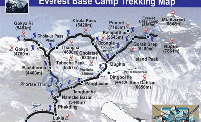
Limi Valley Trekking Map