

The Makalu Sherpani Col Pass Trek is one of Nepal’s most extreme and technical high-altitude treks, linking the Makalu region with the Everest (Khumbu) region. This legendary route crosses three major high passes—Sherpani Col, West Col, and Amphu Labtsa (Amphu Lapcha)—all above 6,000 meters.
This is not a standard trekking route, but a full expedition-style adventure requiring mountaineering skills, glacier travel, ropes, crampons, and expert guides.
“Location & Route”
01: Region: Makalu–Barun & Everest (Khumbu) Regions.
02: Start Point: Tumlingtar / Num.
03: End Point: Lukla or Chukhung.
04: Maximum Elevation:
05: Sherpani Col: ~6,150 m.
06: West Col: ~6,135 m.
07: Amphu Labtsa: ~5,845 m.
Trip Description
Makalu Sherpani Col Pass Trek Region is one of the underappreciated regions in Nepal when it comes to trekking. There are so many trekking opportunities that the region offers, with so many natural and cultural attractions to explore and experience, and yet, the trekkers go for the more popular trekking routes, one of which is Everest Base Camp trek. In no way, the former one offers an inferior trekking experience than the latter one.
Everest and Makalu are in fact neighboring regions, and there is one trek that joins the two of them, and it’s called Makalu Sherpani Col Pass trek. The trek route incorporates significant elements from both the trekking regions
Trip Highlights
- One of Nepal’s most challenging trekking routes
- No crowds – total wilderness.
- Glaciers, icefalls, and high camps.
- Views of Makalu, Everest, Lhotse, Baruntse, Ama Dablam.
- Remote Barun Valley.
- True expedition-level trekking.
- Crossing three legendary high passes.
Itinerary
Upon your arrival at the Tribhuvan International Airport in Kathmandu, a representative from Everest Alpine Trekking will greet you and escort you to the designated hotel. After check-in, you can rest and freshen up. Then we will have a short discussion regarding the trip at our office or in the hotel lobby. Later, we will have a stroll around Thamel Street to make you familiar with the neighborhood.
Note: If your arrival is scheduled in the morning or in the first half of the day, we will take you to Boudhanath Stupa and Pashupatinath Temple before exploring the Thamel market.
First, we will drive to Boudhanath Stupa which is one of the biggest stupas in the world and is the biggest in the country. This Buddhist Stupa with a giant white dome with big Buddha eyes standing in the middle of the mandala represents the Mahayana, i.e., Tibetan Buddhism. The stupa complex is filled with pilgrims and visitors, monks in red robes, pigeons, Himalayan incense sent, etc.
Then, we will move to Pashupatinath Temple which lies on the bank of the holy Bagmati River. It is one of the four prominent Hindu sites in the world. Dedicated to Lord Shiva, Pashupatinath is one of the oldest temples in Nepal built in the 17th century. The temple is flocked by the Hindu devotees every day and every evening, there is an aarti ceremony which is a wonderful sight to watch. We will explore the temple surroundings, watch the ceremony and return to the hotel.
After a delicious breakfast at the hotel, we will proceed for the full day of guided sightseeing in Kathmandu valley. We will visit some of the prominent places in the country that are listed as UNESCO World Heritage Sites such as Budhanilkantha Temple, Patan Durbar Square, and Swoyambhunath Stupa.
Budhanilkantha Temple is an important Hindu temple that is situated at foot of the Shivapuri Hill. It is dedicated to Lord Vishnu and is worshipped by both the Hindu and Buddhist devotees. The giant statue of sleeping Vishnu on the pond is the major statue and highlight of the temple. It is not yet listed as World Heritage Site but is a tentative candidate.
Patan Durbar Square in the Patan district of Kathmandu Valley is one of the three durbar squares in the valley. The palace complex is an excellent example of Newari craftsmanship and architecture with many Hindu and Buddhist temples and monuments. The Patan Museum, Mahaboudha Temple, Krishna Temple, Golden Temple, Bhimsen temple, and Rato Machhendra Temple are some of the notable places here.
Swoyambhunath Stupa/Temple is located on a hilltop overlooking the Kathmandu Valley surrounded by high green hills. It is also one of the oldest sites in the country that is related to the formation of Kathmandu Valley. The stupa houses many Hindu and Buddhist temples, showing the co-existence of religious harmony in the county.
In the evening, we return to Thamel where you can buy or rent trekking gear and equipment
After breakfast, we will transfer to the airport for a flight to Tumlingtar located at an elevation of 950 meters above sea level. During the 50 minutes scenic flight, you will be able to see a range of snow-capped peaks stretching from Langtang to Mt. Everest, Makalu, and Mt. Kanchenjunga.
On arrival at Tumlingtar airport at Tumlingtar, a tiny settlement located on a shelf above the Arun River, we will meet up with our trekking crews. Then we drive to Num for 3 to 4 hours from Kumal village and Khadbari, passing through a sub-tropical forest of Sal trees and more farm fields.
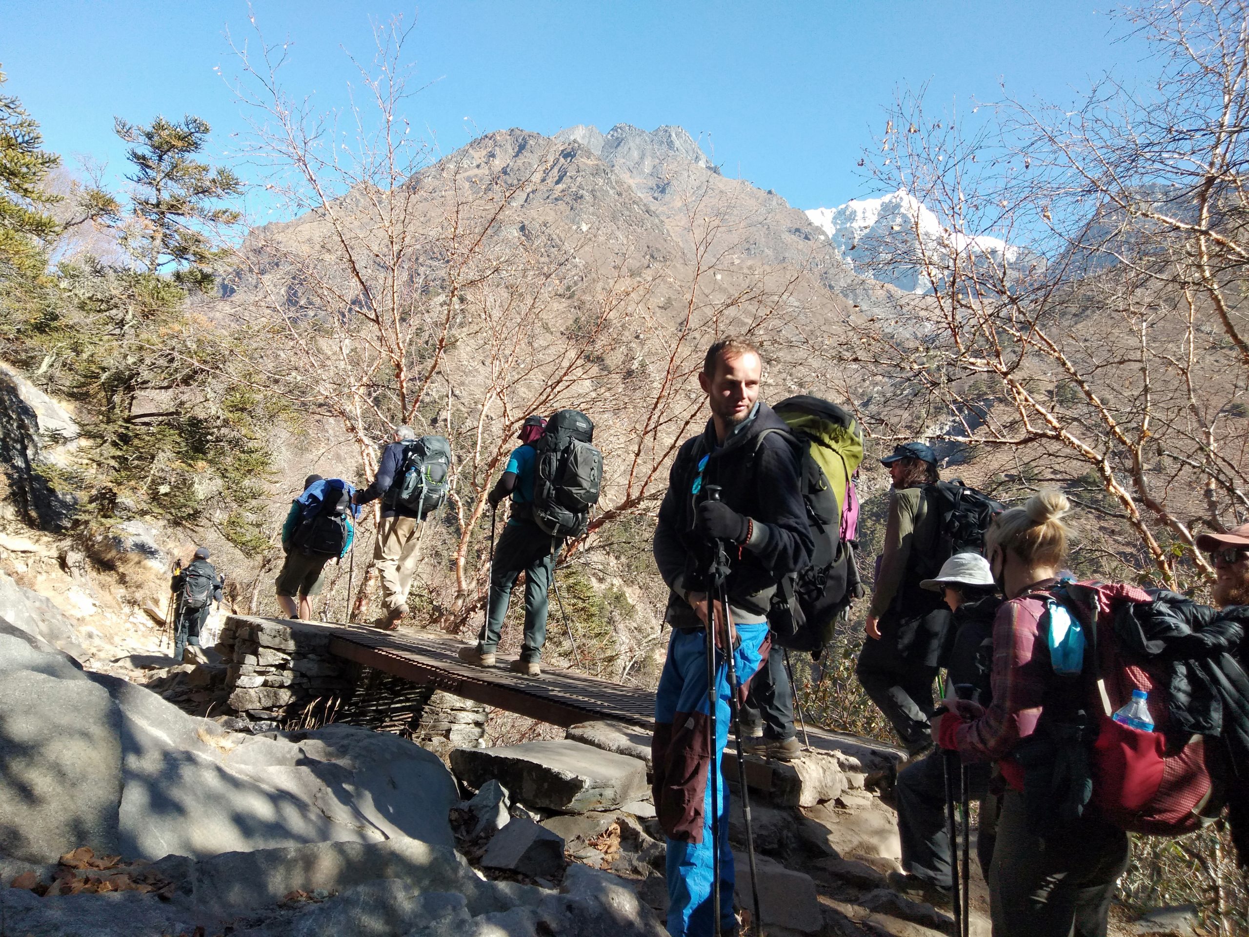
The trekking journey starts today by descending an incredibly steep and terraced slope to the Arun River, which is about 800 meters below us. The lower slopes of this small valley are densely forested, and the trails are rather slick. Once we are at the bottom, we will cross the torrential Arun River via a suspension bridge and make our way back out of the rainforest to our lunch spot.
Following lunch, we will proceed to the suspension bridge and ascend through the forest to the settlement of Seduwa. Seduwa is a community with a tiny health post and a primary school. We have to show our Makalu Barun national park entry permit and TIMS permits in Seduwa.
Soon after breakfast, we start our today’s lovely and short walk through a gentle pass into Murimi Danda. We will pass through many farmlands and rural villages. Then, our trail steadily ascends through millet and rice farms and makes its way through the hillside jungle to the Narbu Gaon. From there, we continue on past fields, forests, and meadows to a school at the bottom of the hill, then down a stone staircase to Tashi Gaon which is a village of Sherpa people. It is the last village on the way to Makalu Base Camp. We arrive in Tashi Gaon for lunch and spend the remainder of the day resting and exploring.
Leaving the final human settlement Tashi Gaon after breakfast, we head towards Khongma Danda today. It will be a difficult day because we will be navigating a number of steep paths at higher heights. We will trek through the woods to a brook, then ascend to a ridge. From here, the trail becomes steeper and passes through a Kharka (grazing region) before leading us to the ridge's summit via a series of stone stairs and little lakes.
Then after walking a short distance, we will reach Khongma Danda. Once at our campsite, we set our camps, relax and explore the surroundings.
We begin our day with stunning vistas of snow-capped peaks and surrounding landscapes along with the glorious sunrise. Then after breakfast, we begin with a tough climb today making our way to the top of the ridge through less steep rhododendron woodlands. We walk along a moderate trail with various ascents and descents, passing by the Thulo Pokhari (large pond) and the Sano Pokhari (small pond). The way from here can be misleading if it has just snowed.
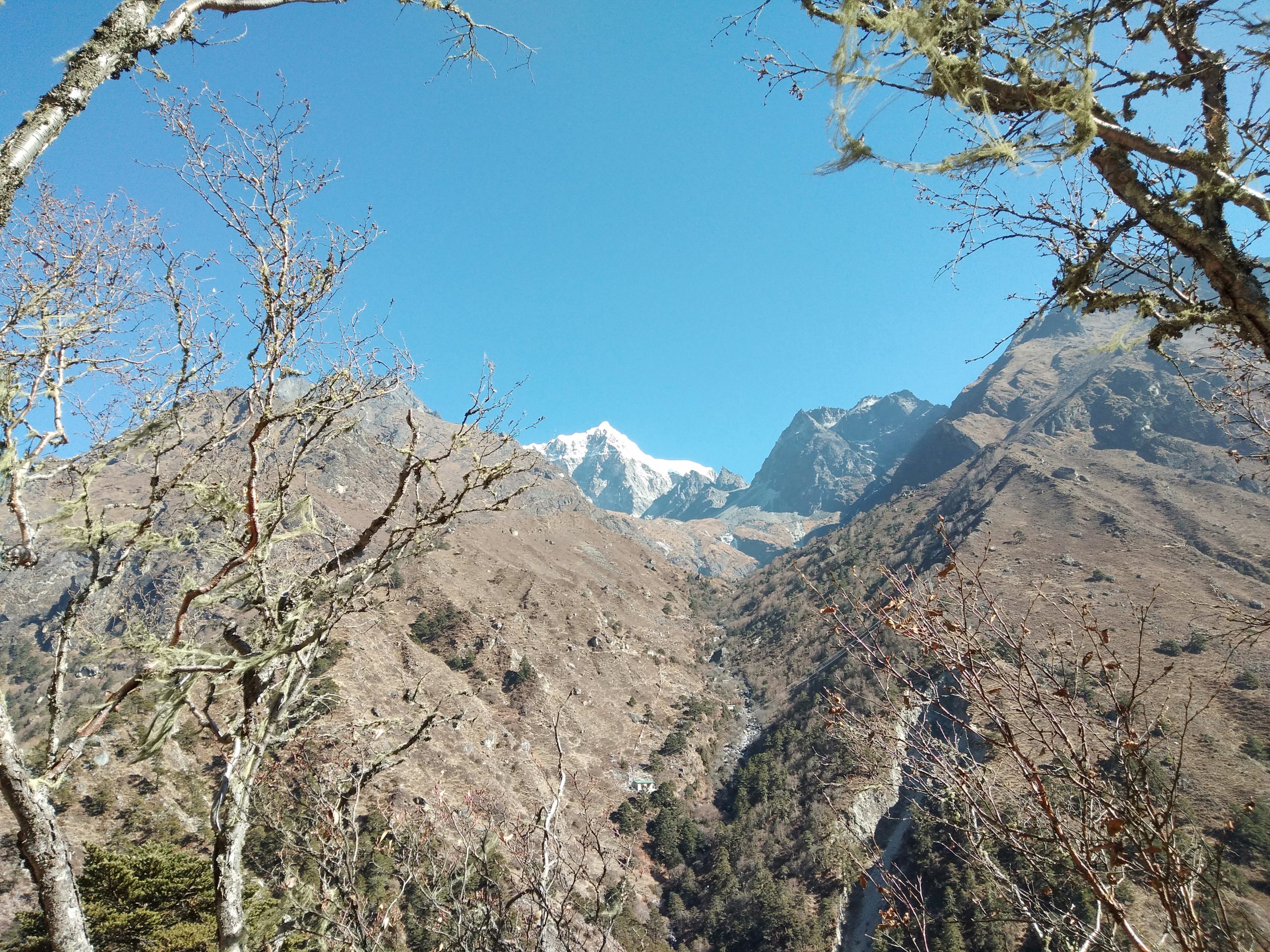
We continue our ascent of Keke La Pass and Tutu La Pass (4075m), from where the views of Chamlang (7,290 m), Peak 6 (6,739 m), and Peak 7 (6105m) are spectacular. Leaving the pass we continue on returning to vegetation and a tiny clearing for camping in the center of the pine, hemlock, birch, and rhododendron woods to arrive at Mumbuk.
Note: From Mumbuk, we can trek further up for 1.5-2 hours and reach Dobato for the night.
After breakfast, we resume our trek with a steep drop into a small valley before crossing the Barun Khola just past Tamatan Kharka. Today’s trek takes around five to six hours, and the terrain gets more difficult as it progresses. The trail becomes difficult and slippery near the end. We then follow the Barun Khola’s northern bank and continue to Yangli Kharka, marked with fluttering prayer flags.
We start early in the morning carrying the packed lunch and plenty of drinking water. We carefully ascend past Nghe Kharka at 3710 meters and reach Shiva Dhara (4310m). You can take a bath on the sacred tap, which cascades down a steep cliff. After exploring Shiva Dhara, we will visit nearby locations such as Parvati Gupha and Ama Bhujung, if time and your interest permit. We enjoy the sights in detail before returning to Yangli Kharka.
We leave Yangli Kharka after breakfast and continue our trek towards Langmale Kharka. A gradual climb from YangleKharka leads to Nehe Kharka at 3750 meters, which is also marked with prayer flags. As we continue, we will pass by a waterfall, Riphuk Herders Camo, and Jhat Kharka Herders Camp at 4210 meters. Then, we make a gentle ascent, reaching Langmale Kharka, a simple lonely stone cottage that provides hot drinks and minimal food, making for a good camping spot.
Note: We can further continue to Merek, a certified campsite by Makalu Barun National Park.
The morning begins with a moderate ascent with views of Peak-4, Chamlang, Peak-3, and Peak-5 and we arrive in Merek. Following a trail to the west alongside a stream from Merek, enjoy views of Hongku Chuli, the Pyramid Peak rising ahead. Then we turn north and enter a side valley where we can see Makalu soaring high above. We continue for an hour on a faint track along the east bank of the stream to reach Shersong, a summertime yak grazing meadow for the Makalu region's Sherpas.
After lunch at the meadow, we resume on a trail that follows the higher mountain path to Makalu Base Camp, one of the highlights of this trip. The base camp is adjacent to a glacial pond next to Baruntse Himal. There is little to see until we arrive at the base camp other than the views we were treated to on our way in.
Makalu Base Camp is also called the Hillary Base Camp and the French Base Camp. These names were given after several old expeditions done by Edmund Hillary in 1952 and the first successful ascent in 1955 respectively
After breakfast, we depart Makalu Base Camp for our next destination, where the trail follows the ablation valley on the west side of Barun Glacier before continuing on the lateral moraine. During the journey, we will be treated to spectacular views of Makalu's West and North West ridges, as well as Everest and Lhotse as we approach the valley's head. The trail becomes rocky and passes through slopes as we progress. After a few hours of walking, we will arrive at Swiss Camp, where we will spend the night.
We will spend an extra day at Swiss Camp for resting and acclimatization.
We begin our walk today with an early start. We will be trekking to a higher altitude today. We rise on a steep trail from Swiss Camp, then gradually ascend and drop to the valley. We'll continue ascending all the way to Sherpani Col Base Camp, where we'll spend the night.
The journey to Baruntse Base Camp takes 7-8 hours today, making it the most difficult day of this journey. We have two passes to traverse: Sherpani Pass and West Col, and navigating them in the middle of the day can be difficult due to weather changes.
We start before dawn and start hiking up the glacier to Sherpani Pass, where we begin to climb on fixed ropes. We continue the trail through a snowy gulley and then up a granite step before reaching the pass's summit. We next descend the other side of the pass to the West Barun glacier valley, from whence we will walk up to the West Col's summit. From the summit, we descend to Hunku Glacier before continuing on to Upper Baruntse Base Camp. We will use ropes to travel through passes.
Today, we will drop into the Hinku valley, passing by five big glacial lakes that stretch out in front of you. These 5 beautiful and serene lakes are called Panch Pokhari in Nepali meaning five lakes. A new vista of peaks opens up in front of us, including Ama Dablam to the west and numerous unidentified summits. We will set up the camps where conditions permit.
From Hinku Valley, we trek for 5 hours today to reach Amu Lapcha Base Camp. We will set our camp at the base camp, rest, and explore the camping surroundings.
We rest for an extra day at the Amu Laptsa Base Camp and make preparations for the last pass, i.e., the Amu Laptsa Pass crossing
Today, we start early in the morning to cross the adventure’s final pass, Amu Laptsa Pass. The hour-long hike to the peak of the pass takes place over rocks, moraine, and icy slopes. The summit of the pass offers a breathtaking view of Lhotse South Face, Lhotse Shar, and Island/Imjatse. After spending an ample amount of time at the pass, we make a roped descent to Imjatse valley, which is 150 meters below the pass.
As the ropes drop needs one by one descent through a sheer rocky wall, time passes. Then we proceed toward the Chukkung Valley in the Everest Khumbu region. After arrival at the village with many lodges, we check-in and rest for the night.
We leave Chhukung after breakfast and walk towards Chhukung Ri from where we can enjoy the stunning views of Makalu and Lhotse Nuptse Wall. Moving on, we pass by the beautiful Sherpa villages of Dingboche and Pangboche, where we will pay our visit to Pangboche Monastery (the oldest monastery in the region) and Dibuche Nunnery. Once we reach Tengboche, we will check-in and rest. Later, we will explore the largest monastery in the Kumbu region, the Tengboche Monastery is located in a magnificent meadow with a 360-degree panoramic view of Everest.
The trail descends from Tengboche through lovely rhododendron and pine forest, with views of the Dudh Kosi river valley, Khumjung, Namche, and Kongde mountains. We will cross the bridge at Punggi Tenga and climb up Senasa which is the trail junction for Gokyo, Khumjung, Namche, and Tengboche, below the Khumjung settlement. Then we continue to Khumjung for lunch and a look around before descending to Namche.
The walk comes to an end today. We walk downhill from Namche to the Dudhkoshi River, then ascend to Monjo via the Sagarmatha National Park entrance point. We will reach Phakding village after trekking through a comparably low, warm river valley. Finally, we cross the river one last time and pass through numerous small Sherpa settlements before arriving at Lukla for our final overnight break.
We bid farewell to the Himalayas and board the early morning flight from Lukla to Kathmandu. Upon reaching Kathmandu and checking in at the hotel, the remainder of the day is on leisure.
You can stroll around the streets of Thamel, buy some souvenirs for friends and families, check out some great restaurants or cafes, or visit the best spa in the town. In the evening, we will dine in at an authentic Nepalese Restaurant to enjoy a traditional Nepali meal with a cultural event.
Approximately 3 hours prior to your scheduled flight, a representative from Himalayan Trekkers will transport you to the airport. If the departure is scheduled in the late evening, you can stroll around the Kathmandu markets for the one last time after breakfast.
Cost Includes
- 1.Airport & Ground Transportation.
- Airport pick-up and drop-off (international & domestic).
- Private ground transport for Kathmandu–Tumlingtar–trailhead and return.
- All official transportation as per itinerary.
- 2.Accommodation:>
- Hotel accommodation in Kathmandu (twin-sharing, standard category).
- Teahouse or lodge accommodation in lower trekking areas.
- Fully supported camping accommodation in remote and high-altitude sections.
- Expedition-grade tents (sleeping, dining, kitchen, toilet tents).
- 3. Meals:>
- All meals during the trek (breakfast, lunch, dinner).
- Nutritious high-altitude meals prepared by professional trekking cooks.
- Hot drinks (tea, coffee) during trekking days.
- Safe drinking water (boiled or treated).
- 4.Trekking & Climbing Staff:>
- Government-licensed experienced trekking guide.
- High-altitude climbing Sherpa(s) for Sherpani Col, West Col & Amphu Labtsa.
- Cook, kitchen staff, and support crew.
- Porters to carry group equipment and personal luggage (as per weight limit).
- Staff salary, food, accommodation, insurance, and equipment.
- 5.Permits & Documentation:>
- Makalu-Barun National Park Permit.
- Sagarmatha National Park Permit.
- Khumbu Pasang Lhamu Rural Municipality Permit.
- TIMS card (if applicable).
- All government taxes and service charges.
- 6.Expedition & Technical Equipment (Group Use):>
- Fixed ropes for high passes.
- Snow bars, ice screws, anchors (group safety gear).
- Glacier travel equipment.
- Satellite phone or emergency communication device (group use)
- First-aid medical kit with altitude medicine.
- Solar panels or generator for lighting/charging (group use).
- 7.Safety & Logistics:>
- Route fixing and pass-crossing support.
- Weather monitoring and acclimatization planning.
- Emergency rescue coordination assistance.
- Comprehensive logistical planning and support.
Cost Excludes
- 1.International & Domestic Flights:>
- International airfare to and from Kathmandu.
- Domestic flights (if applicable).
- Excess baggage charges.
- 2.Nepal Visa & Travel Insurance:>
- Nepal entry visa fees.
- Personal high-altitude travel & rescue insurance (mandatory).
- 3.Personal Equipment:>
- Personal mountaineering gear (boots, crampons, ice axe, harness, helmet).
- Sleeping bag and down jacket (unless rented).
- Trekking clothing and personal items.
- 4.Meals in Kathmandu:>
- Lunch and dinner in Kathmandu (unless specified).
- Snacks, bakery items, and alcoholic beverages.
- 5 Personal Expenses:>
- Personal snacks, energy bars, chocolates.
- Battery charging, Wi-Fi, or communication fees (where available).
- Laundry, hot showers, and bottled drinks.
- Tips for guide, Sherpa, porter, and staff (customary but optional).
- 6 Emergency & Evacuation Costs:>
- Helicopter rescue or medical evacuation costs.
- Hospital and medical treatment expenses.
- 7.Delays & Unforeseen Costs:>
- Costs due to weather delays, route changes, strikes, or natural disasters.
- Extra nights in Kathmandu beyond itinerary.
FAQS
The Makalu Sherpani Col Pass Trek is an extreme, expedition-style high-altitude traverse that links the Makalu region to the Everest (Khumbu) region, crossing Sherpani Col, West Col, and Amphu Labtsa Pass. It is considered one of the most challenging treks in Nepal.
Sherpani Col lies between Makalu and Baruntse, at approximately 6,150 meters, inside the Makalu–Barun region, connecting to the Everest area via high glaciers.
This trek is classified as extremely challenging / expedition level. It requires:
01: Prior high-altitude trekking or climbing experience
02: Glacier travel skills
03: Rope, crampon, and ice-axe use
04: Strong physical and mental endurance
05: This trek is not suitable for beginners.
01: Sherpani Col: ~6,150 m
02: West Col: ~6,135 m
03: Amphu Labtsa Pass: ~5,845 m
04: All three passes involve glacier crossings and technical sections.
The trek typically takes 24 to 32 days, depending on:
01: Weather conditions.
02: Acclimatization needs.
03: Team strength and logistics.
04: Extra contingency days are strongly recommended.
The best seasons are:
01: Spring (April–May): Best snow and ice conditions
02: Autumn (September–October): Stable weather but colder
03: Winter and monsoon seasons are not recommended.
Yes. This trek must be done with experienced, licensed climbing guides and Sherpas. Independent trekking is unsafe and strongly discouraged due to technical and rescue challenges.
This is a fully supported camping trek:
01: Expedition tents.
02: High-altitude camps.
03: No teahouses beyond lower villages.
04: Meals prepared by professional cooks.
Required permits include:
01: Makalu–Barun National Park Permit
02: Sagarmatha National Park Permit
03: Khumbu Pasang Lhamu Rural Municipality Permit
04: Restricted Area Permit (if applicable)
01: Participants must use:
02: Mountaineering boots
03: Crampons
04: Ice axe
05: Harness and helmet
06: Ropes and carabiners
07: Snow protection and safety gear
Yes. Since the trek crosses above 6,000 meters, the risk of Acute Mountain Sickness (AMS), HAPE, and HACE is significant. Proper acclimatization and medical preparedness are critical.
You should be able to:
01: Trek 6–8 hours per day at high altitude
02: Carry a pack in cold and technical conditions
03: Perform safely on snow, ice, and steep terrain
04: Excellent cardiovascular fitness is essential.
No. This is one of the least-traveled routes in Nepal. Many groups will see no other trekkers for weeks.
01: Mobile networks are unavailable.
02: Satellite phone or communication devices are recommended.
03: Emergency communication is essential.
Rescue is very difficult and weather-dependent due to altitude and remoteness. Helicopter evacuation may not be possible at high camps or during bad weather.
Costs typically range from USD 5,400 to 9,500+ per person, depending on:
01: Group size: 1/15 pax.
02: Number of guides and Sherpas
03: Expedition equipment
04: Duration and logistics
Yes. It is often combined with:
01: Baruntse Expedition.
02: Makalu Expedition approach.
03: Everest traverse routes.
These combinations require additional permits and time.
01: Extremely cold temperatures at high camps.
02: Strong winds on passes.
03: Rapid weather changes.
04; Snowstorms possible even in peak season.
With experienced guides, proper equipment, acclimatization, and contingency planning, the trek can be completed safely. However, it remains one of the highest-risk trekking routes in Nepal.
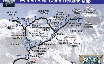
Makalu Sherpani Col Pass Trek Map